A new mental map for Lexington
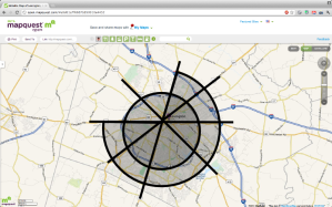
I grew up in Omaha, NE which is geographically organized in a familiar Cartesian coordinate system (ie a grid). There are 8 major roads running East-West, and a series of numbered streets increase in value as you move from East to West. Once you understand this model of the city of Omaha, you can rather easily visualize where “156th and Dodge St.” is located*. I’ve struggled to do the same with my new home of Lexington, KY. It is neither arranged on a N-S axis, nor follows a common grid pattern outside of downtown. As I am involved in a company that provides indoor navigation services, I wanted to try my hand at designing for the outdoor world. Additionally, improving the communication of the design of transportation systems seems to be a popular thing these days. So, I offer you the following as a potential alternative mental model of Lexington’s geographic layout:
This map shows a quick overlay highlighting the major roads in Lexington. You’ll notice that there are roughly two rings around the city (New Circle Road is the inner ring, and Man-O-War Boulevard/I-75** form the outer ring). There are also 4 major paths that cut through the city (I say paths because there are actually 8 named roads, more like spokes). If we assume that downtown is a finite point (which it is not), then these 4 paths intersect each other near the center of the concentric circles (there is a slight North shift in actuality).
This happens to form the basis for a polar coordinate system, wherein we can describe any location in Lexington based on an angle from North, and a radius from the center point (or, as it works out in this case, CentrePointe). For instance, the University of Kentucky is located between 135° and 180° (ie South-Southeast) at a radius of 0.5 (somewhere between the origin point and New Circle Road, which I assigned the radius value of “1”). It is important to note that this is not a geographically accurate map. It might be better described as a diagram, similar to the famous London Tube Map.
Realizing that many people are less familiar with the Polar Coordinate system than they are with the Cardinal Directions, I decided to offer the city of Lexington chopped into 24 slices. These slices are formed from the directions on a 16-point Compass Rose, and a radius of 0 (inside New Circle), 1 (between New Circle and Man-O-War/I-75), and 2 (outside Man-O-War/I-75). Here, the University of Kentucky is located in SSE0. The amorphous green outer band is meant to symbolize the ring of horse farms that surround Lexington. The other colors were selected more arbitrarily (because I like RGB). If you have a keener eye for design, feel free to share something that uses color more purposefully, or at least aesthetically.
So, do I expect this nomenclature to catch on? Heck no! But armed with this oversimplified mental model, perhaps more people can start using a more colloquially-relevant Polar coordinate system to more concisely communicate locations in Lexington. For instance, I would describe the location of University of Kentucky as, “between Nicholasville Road and Tates Creek Road***, inside New Circle.” The Hamburg Pavilion shopping center is located, “between Richmond Road and Winchester Road, just inside Man-O-War Blvd.” I favor this method because of its precision. Based on my casual anecdotal observations, my proposed system must overcome the incumbent coordinate system, which is primarily landmark-based. Most people I have observed make references relative to UK, Hamburg, Fayette Mall, Lexmark, Keeneland/Bluegrass Airport. “Check out this new restaurant, it’s by the Mall.” While this is useful for conversations among locals, with sufficient local knowledge of these landmarks, I don’t think this helps as much for new visitors. However, it’s possible that I am wrong and that these major landmarks are easier to quickly commit to memory than the 9 major spokes (Newtown, Broadway, Winchester, Richmond, Tates Creek, Nicholasville, Harrodsburg, Versailles, Leestown) and two loops. As long as the landmarks maintain stability (I don’t think UK or Keeneland will be relocated any time soon), then these could serve as a reference mechanism as reliable as the named roads.
If you have any improvements to this model, please share them in the comments!
* A more widely familiar model than Omaha may be New York City. For example, Radio City Music Hall is located on W. 54th Street, between 5th and 6th Avenue.
** In particular, I’m referring to the section of interstate where I-64 and I-75 are merged, as this helps complete the Man-O-War loop. For this model, I ignore I-75 once it splits back off and heads South, as this could be confused as an additional radius demarcation.
*** Tates Creek Road was not one of the the main thoroughfares listed in my model, but is certainly a major spoke in Lexington’s road system.


I really enjoyed this concept! Depending on which spoke I am near at the time (normally Harrodsburg or Nicholasville, or even Clays Mill), I tend to speak as that road runs due north-south. While this is slightly inaccurate, I feel the simplicity that this introduces in the conversation is worth the deviation from the map. Of course, as the scope of the map in discussion expands, these roads pure directions and relations to other spokes must be considered differently. Anyway, excellent approximation!
I agree, that does simplify it even further! For the point of communicating directions, simplicity often trumps precision. You’re really just looking to distinguish between two possible options: turn left or right at given road. Thus, Northward or Southward is valid, even when the true heading is more precisely “Northwest” than “North”.
PS: It would be awesome to see your mental model sketched up (even a photo of a quick paper sketch would be cool).
Excellent information. Thanks!